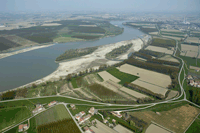
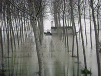
 The SPA "Viadana, Portiolo San Benedetto Po, Ostiglia" is divided into four main territorial branches - only partially located in the area of the Oltrepò - and belongs to the European ecological network Natura 2000. With more than 7,000 hectares it is the largest protected area of the Parks System Oltrepò Mantovano and contains all the natural assets (running water, sandbanks, oxbow lakes, beehives, riparian forests) and anthropogenic features (poplar groves, arable land, sand pits and clay, hydraulic defenses, river docks, urban areas, civil and industrial infrastructure) which is typical of the middle course of the Po. In environmental terms, the Po with its flood plains is The SPA "Viadana, Portiolo San Benedetto Po, Ostiglia" is divided into four main territorial branches - only partially located in the area of the Oltrepò - and belongs to the European ecological network Natura 2000. With more than 7,000 hectares it is the largest protected area of the Parks System Oltrepò Mantovano and contains all the natural assets (running water, sandbanks, oxbow lakes, beehives, riparian forests) and anthropogenic features (poplar groves, arable land, sand pits and clay, hydraulic defenses, river docks, urban areas, civil and industrial infrastructure) which is typical of the middle course of the Po. In environmental terms, the Po with its flood plains is the largest widespread natural area in the province of Mantua and, more generally, of the Po Valley. The presence of the river has allowed large portions of territory to escape those phenomena that, beyond the banks, led to the dismantling of natural formations for agriculture and human settlements. Reservoir of biodiversity and vital link between the natural systems of the Adriatic, the Alps and the Apennines, the Po and its tributaries are central to the ecological network of the Po Valley. the largest widespread natural area in the province of Mantua and, more generally, of the Po Valley. The presence of the river has allowed large portions of territory to escape those phenomena that, beyond the banks, led to the dismantling of natural formations for agriculture and human settlements. Reservoir of biodiversity and vital link between the natural systems of the Adriatic, the Alps and the Apennines, the Po and its tributaries are central to the ecological network of the Po Valley.
|
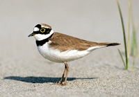
 Therefore, the faunal richness of the Special Protection Area (SPA) is not surprising, especially with regard to the birds (over 200 species), including the black kite, osprey, Montagu's harrier, the bee-eater, the cormorant, the courier small, the common tern, little tern, woodcock and golden oriole. Among the mammals, in addition to the hedgehog, hare, weasel, and numerous species of small rodents, we find the rate and the skunk; between amphibians and reptiles crested newts and dotted, green frog, tree frogs and toads, common emerald, in addition to the lizard, the rat snake and the grass snake. Among the fish, finally, the increasingly rare sturgeon, mullet, eel, shad, carp and catfish. Therefore, the faunal richness of the Special Protection Area (SPA) is not surprising, especially with regard to the birds (over 200 species), including the black kite, osprey, Montagu's harrier, the bee-eater, the cormorant, the courier small, the common tern, little tern, woodcock and golden oriole. Among the mammals, in addition to the hedgehog, hare, weasel, and numerous species of small rodents, we find the rate and the skunk; between amphibians and reptiles crested newts and dotted, green frog, tree frogs and toads, common emerald, in addition to the lizard, the rat snake and the grass snake. Among the fish, finally, the increasingly rare sturgeon, mullet, eel, shad, carp and catfish. |
|
|
From the point of view of the road pedestrian and cycle, the four compartments of the SPA are well connected with each other through the Eurovelo routes and the bicycle path of the SIPOM. The areas close to the river, which offer very suggestive stretches, are accessible through the network of dirt roads in the service of productive and recreational activities that take place in the floodplain. The access to motor vehicles is permitted only in the sections indicated by appropriate signs. There are, in many places, interesting service roads along the banks of the river ("towpaths"), once used to tow row-boats and boats against the stream. |
